

Description
ARTICLE FOR INFORMATIONAL PURPOSES ONLY
King Charles III of Spain ordered the creation of an archive in Seville to house all documentation relating to the Indies that had been deposited until then in Simancas, in the Council of the Indies in Madrid and in the Casa de Contratación in Seville. It was the first archive in the modern world conceived not for administrative purposes, but as a source of information for future historians. The expectations were met, and in its almost two and a half centuries of existence, the collections of the Archive of the Indies have been consulted by thousands of scholars of American subjects.
Since its creation in 1785, when the first batches of documents arrived in Seville, archivists and researchers found in its 40,000 files a long series (currently 6,379 pieces) of maps, plans and drawings folded to fit the size of the file. At the end of the 19th century, and especially on the occasion of the celebration of the centenary of the Discovery of America, the idea of creating a new Maps and Plans Section arose, made up of all the maps and plans found, which would be extracted from its file, although leaving a record in it. The aim was to locate all the pieces immediately and to preserve them in the most suitable technical conditions. A pioneer in the creation of the new section was the Sevillian archivist Pedro Torres Lanzas, to whom we owe, among other catalogues, the publication of the one referring to Mexico (Seville, 1900). The number of pieces of Mexican origin that he discovered amounts to 516. Over the years, the technicians of the Archive increased the number, which in 1985 was valued at 275 more.
The sending of this graphic information from the American nations to the mother country, mainly to the Council of the Indies, was a constant since the first years of the presence of the Crown of Castile in the New Continent. Foundations of towns and religious institutions, creation of bishoprics, construction of public works, military or civil buildings, geographical expeditions, surveying of large areas of maps, etc., required the permission of the mother country to begin them and also the approval when the work was finished. In many cases it was the monarchy itself that issued orders (sometimes printed) for certain tasks to be carried out, such as the one in 1711 in which it was requested that designs and maps of all the ports and squares of the Indies be sent to Spain, which gave rise to a cascade of graphic information. As can be expected, the plans and maps were usually accompanied by an extensive information file. It would seem unnecessary to highlight here the extraordinary value that the collection of maps and plans and the information attached to them has for the history of Mexico and other American nations.
For the present facsimile edition, a sample consisting of five Mexican plans and maps has been chosen, combining the criteria of quality of their execution, value of their content, geographical variety and time.
MAP OF THE TOWN OF TETELA DE OCAMPO. Year 1581.
It has the signature M. P. México 31 and comes from the file 1.529 of the Indiferente General. Pen drawing and colored with watercolor in ochre and gray tones, 443 x 703 mm. It was commissioned by the corregidor don Cristóbal Godínez y Maldonado on July 9, 1581, and was sent to Spain together with an informative file that is also preserved in the General Archive of the Indies. It was described by P. Lanzas Torres in his Catalogue of Maps and Plans of Mexico. General Archive of the Indies, Madrid, 2nd ed. 1985, p. 34.
Of the towns called Tetela that have survived from the Spanish era, we must identify the one represented on our map with the one called Tetela de Ocampo (State of Puebla) because of the series of towns that appear in its surroundings: San Pedro de Hueytentlán, San Juan Tututla, etc. Each town is represented by a larger building that, by the cross that crowns it, refers to the church, which is surrounded by smaller houses. Rivers and roads are well represented, and on these there are pedestrians and pack animals loaded with their bundles.
The footnote says “This town of Tetela has four hundred and fifty residents, with no more than one hundred old people outside. and it was signed by the mayor, Juan Gonçález (signature). By order of the mayor, Marcos del Cuenca, scribe.”
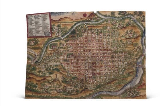
MAP OF ANTEQUERA (OAXACA DE JUÁREZ), ACCORDING TO THE PATTERN OF THE SANTA IGLESIA CATEDRAL. Year 1771.
It bears the signature Mexico 543, and has been extracted from file 2,591 of Mexico. Its dimensions are 410 x 302 mm. It represents a top-down view of the city of Antequera, in the Valley of Oaxaca, in New Spain.
It has a very good execution technique, with the use of various colors. It shows the city located in a bend in the river, with a Renaissance layout based on streets that cross perpendicularly. On the outskirts of the town, in contrast to what happens in the center, the quarters or blocks share housing with orchards or trees, as occurs in current times. An aqueduct or I/targeal/ provides drinking water to the town.
As the plan has an ecclesiastical purpose, since it was commissioned by the sacristan of the Cathedral church, religious buildings and institutions predominate, which are indicated on the plan with capital letters, ranging from A (Cathedral church) to U (Coronation). Then, 40 main points of urban toponymy are indicated: schools, warehouses, customs, tobacco factory, bridges, etc.
On the explanatory label of the letters and numbers, the heraldic shield of Antequera stands out, with the arms of Castile and Leon appearing on the peripheral quarters.
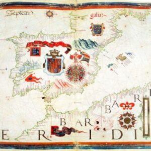
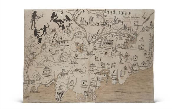
MAP OF NUEVA GALICIA (STATE OF JALISCO). Year 1550.
Signature M. P. Mexico 560. From the Justice Section, file 104. 437 x 315 mm.
One of the oldest maps of the city of Guadalajara and surrounding towns, as it was completed on January 8, 1550. Using a poor cartographic technique, but still normal in the mid-16th century, the rivers, lagoons and the great Lake Chapala are represented by simple drawings at the bottom, the mountains and hills and the roads (in the right corner “Camino de México”). To indicate the importance of the towns, the size of the house that represents it is enlarged or several houses are grouped together, as occurs with the city of Compostela or Izatlán; Guadalajara is presented by a grid divided by the two main streets that cross perpendicularly. Many towns appear, located on the right side of the map, which have a cross on the roof. The meaning of this is explained in a note on the back that says: “All the towns that have crosses are from the governorate of Mexico. The licenciado Hernando Martínez de la Marcha.”
The only boundary indicated is on the right margin and says: “The Province of Mechuacán is on the part of this painting outside of these mountains.”
The important mines are not unlocated: Rich Mines of the Çacatecas, Mines of the Tepeque River, Silver Mines, Mines of Guachinango. A contemporary hand placed under many towns the note that they were uninhabited. The indigenous populations, represented in the upper part of the map, are located on high mountains and their inhabitants, naked and with bow and arrow. Scenes of human sacrifices are drawn in the upper left corner. The writing used is the so-called annuities or privilege, the best that was done in the Crown of Castile in the 16th century.
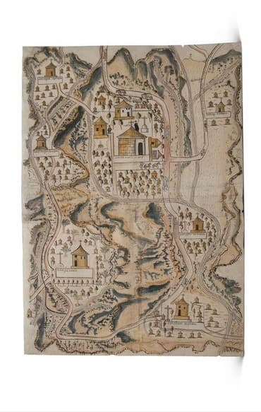
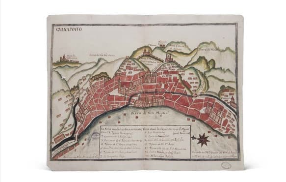
GUANAJUATO MAP. 18th century.
It bears the signature M. P. Mexico 601, and comes from file 1,783 of the Indiferente General of the Archive of the Indies. 397 x 310 mm. It is a very schematic map of the city of Guanajuato, seen from the top of the Cerro de San Miguel. Although not very elaborate, the representation technique is good, something common in the 18th century, and the North is indicated by a star and the exact position of Guanajuato “Located at 267 degrees 30 minutes of longitude and 22 degrees 50 minutes of latitude, in the sign of Virgo”. The type of writing used places the preparation of the map in the last third of the 18th century.
The city is not presented to us with the grid layout typical of the Renaissance, but with a structure that responds to a population that, without prior planning, grows as the number of its inhabitants increases. The main geographical features, such as mountains, sierras, rivers, are clearly highlighted, and in the urban area, next to the three roads (Pasdita, Alta and Marfil), the religious buildings occupy a prominent place in the drawing, starting with the parish church in the centre of the city. In the explanatory plaque on the map, there are 14 numbers, corresponding to as many ecclesiastical institutions, except for the last two, which correspond to the royal houses, the royal treasury and the public market. But the draughtsman forgot to put most of the 14 numbers on the map, as he only reaches 16, which corresponds to the church of San Juan.
The greatest wealth of Guanajuato resided in its silver and gold mines, which are indicated in detail: Valenciano Mine, Mellado Mine, Rayas Mine, Serena Mine, and in the lower left corner the note: “It is the richest Royal Mine in New Spain.”
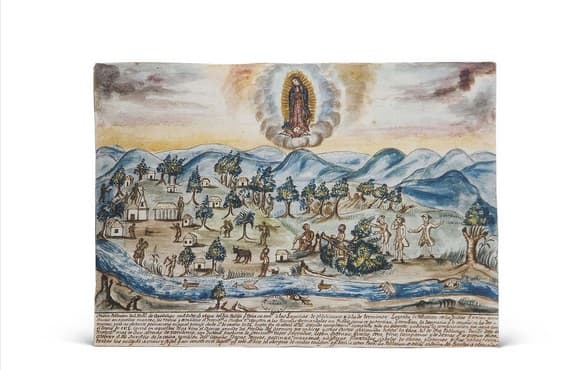
PANORAMIC VIEW OF THE VILLA OF SALTO DE AGUA (STATE OF CHIAPAS, MEXICO). Year 1795.
It bears the signature M. P. Guatemala 271 bis, and comes from the file Guatemala 452. Its dimensions are 312 x 215 mm. Pen drawing and later colored in watercolor.
It represents the work carried out for the foundation of the town of San Fernando de Guadalupe (today Villa de Salto de Agua) carried out in the years 1794 and 1795 under the direction of the Intendant of Chiapa, Don Agustín de las Cuentas, who suffered a serious accident when clearing work was being carried out. Due to the From the poster or legend of the Vista and from the file that was sent to the Crown, we know that, after the reduction of the neighboring Indians, the new town was built, in which 300 souls were settled, with a church equipped with the necessary ecclesiastical trousseau, domestic animals, fruit trees, canoes, etc. In this way, communication and trade with New Spain was opened through the Tulijá River.
The pictorial representation, rather idealized, shows in the lower plane the direction of the river current, a pier and sailing and rowing boats; the intendant and his collaborators in 18th century attire; the distribution of the houses and church; and the Indians working on the felling of trees, transporting firewood and even fishing in the river. The entire scene is crowned by the representation of the Virgin of Guadalupe.
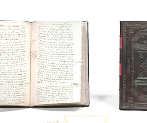
The five maps presented in a folder with complementary study. Facsimile edition of 2002, numbered, limited and certified.
Retail Price: 572 €. Consult us any questions, indicating the item reference.